info@biomedres.us
+1 (502) 904-2126
One Westbrook Corporate Center, Suite 300, Westchester, IL 60154, USA
Site Map

Received: July 13, 2017; Published: July 24, 2017
Corresponding author:RAE Z HAliyev, Institute of Erosion and Irrigation NAS of Azerbaijan
DOI: 10.26717/BJSTR.2017.01.000216
The results of the conducted studies revealed that soil erosion agitatedly reduces the humus content. If the reserves of 0-50 cm of the layer are not washed away by mountain- Brown soils - 168 tons per hectare, in a very weakly washed-156t / ha, slightly washedoff 135 tons / ha, medium-washed-108 tons / ha, strongly washed -65 T / ha, and in very strongly washed-32 c / ha. In eroded soils not only reduce the content of common humus, but changes and its qualitative structure, narrows the ratio of carbon to nitrogen, thereby increasing the amount of fulvic acid and reduces the coefficient of mobile forms of humic acids, etc. Fertile, eroded, medium washed away, not washed away, slightly washed away, strongly washed away, differentiated, fertilizers, etc. In the midst of great development of Azerbaijan received erosion causing Washout, erosion and deflation. It is expressed most clearly in the soils, cultivated in conditions of impoverished and sediments rain fed agriculture.
To solve problems of completeness enough land management, erosion or potentially dangerous erosion you must deeply know every piece of array management, its features that can influence the choice of crops on those or other general events or private receptions machinery. Obtaining such data is possible only as a result of large-scale surveys the territory. Depending on the degree of loss of soil, upper horizons generally emit very weak, medium and very strong in difference of soil. The stronger are affected by erosion of the soil, the more they differ from their analogues on chemical, granulometric composition and physico-chemical properties, water, air and thermal regimes of biogenic and other indicators, the totality of which affect their fertility and erosion resistance. The change of particle size distribution of soils in the development of erosion is determined primarily by the degree of homogeneity of the depth profile. If the soil is fertile, soil gets washed away the variety little different on this basis. In soil silt fraction decreases markedly. In eroded soils changes the mineralogical composition of the plow layer due to its change in depth of the soil profile. A very big change of particle size distribution of the silnosmytyh soils. Soil erosion reduces excitedly humus content.
If the stock 0-50 cm layer in nesmytyh mining and ostepenjonnyh Brown soils is 168 t/ha, in a very slabosmyth-156t/ha, slobosmyth-135 t/ha, srednesmyth-108 t/ha, silnosmyth-65 t/ha, and in very silnosmyth-32 t/ha. In eroded soils not only decreases the total humus content, but changes and its qualitative structure, narrows the ratio of carbon to nitrogen, thereby increasing the number of fulvic acid and decreases the ratio of mobile forms of humic acids to fulvoacids. Decreases correspondingly the contents of mobile forms of humic acids. According to A.a. Tanasienko, these changes are the stronger, the more are affected by erosion of the soil. Reduce humic acids leads to lower fertility, conservation of soil resistance to deterioration. I.e., the stronger the soils are affected by erosion, the less they contain humus. This reduction, in General, proportional to the reduction of nitrogen in the soil. In addition, eroded soils percent digestible forms of nitrogen, nitrate and ammonia in particular forms, below than differences of soil. In soils detected by reduction of gidrolizuemogo nitrogen and nitrate -2.0 1.5 times. Shortage of available forms of nitrogen is one of the important reasons for the decline of fertility of eroded soils. Regularity also reveals decreasing r20 in srednesmytyh soils by 30% and silnosmytyh-more 50%. Reduction of organic phosphates and phosphorus forms insoluble increase leads to deterioration of phosphorus nutrition of plants.
In eroded soils are often reduced content of potassium. Thus, its agrochemical characterization of soil washed away are substantially different from nesmyth. Hence arises the need for differentiated fertilization in soil with varying degrees of erosion. Eroded soils differ significantly from physical properties. In the eroded soils decreases the content of structural aggregates. So, if in the upper horizon mining nesmyth Brown soil content of the aggregates is 52% very slabosmyth-48%, slabosmyth-42%, srednesmyth-30%, silnosmyth 18%, and in very silnosmyth-8%. The number of units of less than 0, 25 mm increments (Table 1). Soils are distinguished from eroded visible differentiation of soil profile and greater capacity. Well allocated arable and 2 layers. In the past appears gray-Brown shade effect of alluvion horizon. Subsurface layer is visibly detectable seal and meet the selection of carbonates. Structure of silt-clotted, and Virgin soil-clotted well expressed. The degree of erosion for each soil type is set, depending on which part of the soil profile washed away or deformed horizon from which topsoil is emerging, what is the average percentage yield compared to harvest on nejerodirovannyh soils, and the steepness of slope in degrees. The degree of erosion of soil also depends on the shape of the slope, its length and exposure, the correctness of management, anti-erosion of sustainability, which includes a variety of mechanical, chemical and physical properties. Therefore, on the slopes of the same slope soils can be one, but different subtype of erosion.
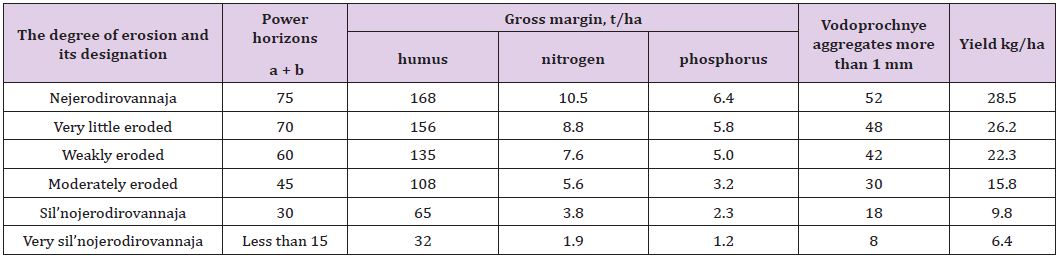
Table 1: Diagnostic indicators of varying degrees of erosion the mountain-ostepenjonnyh Brown soils.
The average harvest is a very important indicator in determining the degree of erosion. In the field soil fertility was determined visually by morphological hallmark of a soil profile and as plants on this site. From the data (Table 1). It can be seen that as the degree of erosion decreased the power of the horizon a + b and reserve of humus within certain limits. It should be noted that the supply of humus (in tones) is calculated taking into account the nitrogen and phosphorus. In addition, data on crops as listed in the classification of eroded soils, somewhat understated. Follow our long-term studies have shown that the harvest of winter wheat at very little eroded mountain-Brown soils in the rolling average is reduced to 10% for medium-up to 25% of eroded, and the silnojerodirovannyhup to 75% compared to harvest on nejerodirovannyh soils. Taking into account local characteristics of soils, we adopted the following grouped by degree of soil erosion. Jerodirovannost land, which is set depending on the steepness and slope exposure, the depth of local bases, erosion degree of erosion, the nature of the underlying rocks, belonging to one or other agricultural lands. Graduation steepness of slopes for arable land were taken as follows: 0-1; 1-3; 3-5; 5-8; 8-12 and more than 12. Other land: 0-1; 1-3; 3-5; 5-8; 8-12; 121-20; 20-30; 30-45 and more. On the slopes following graduation be taken exposure: North, Northeast, Northwest, East, West, South West, South East and the South. Gradation of depth of local bases were taken following erosion: 0-20; 20-50; 50-100; 100-150; 150-200; 200-3004 300-4004 400-500; 500-600; 600-800; 800-1000 m and more. According to the degree of erosion of different categories of eroded land kept as soil one degree of erosion and their complexes.
Also take into account the nature of the underlying rocks and their density. For each of the selected groups and categories of eroded land have been given recommendations on their use and application of counter-erosion activities. The basis of allocation of eroded land are soil maps that reflect all the contours of eroded soils and farmland. Used and supporting special cards steepness, exposure, slopes and depth of local bases of erosion. In recent years, there has been significant growth in the areas of eroded soils, associated with the thoroughness of research and allocation of eroded land, which previously were not considered. First of all, the question arises on the diagnostic indicators to assess the extent of erosion of the soil. Sometimes use indicators that determine risk of erosion. For example, in some cases, assessment of erosion of arable soil set based on the data distribution of arable land on the slope. Of course, the steeper slopes, so all things being equal on them increases the degree of soil erosion. However, these are not always equal terms, so the soil more steep slopes may be less inclined than are affected by erosion (Table 2) as can be seen from table 6, in the north-eastern part of the Greater Caucasus arable land on terrain conditions are more favourable than the South-East or South of the Greater Caucasus. Therefore, the soil cover is relatively less erodirovannyj. This is largely due to the relatively higher conservation soil stability, favourable rainfall and pochvozashhitnoj role of vegetation. Soil erosion studies in Azerbaijan showed that factor exposure slopes more often affects distribution of eroded soils than the steepness of slopes.
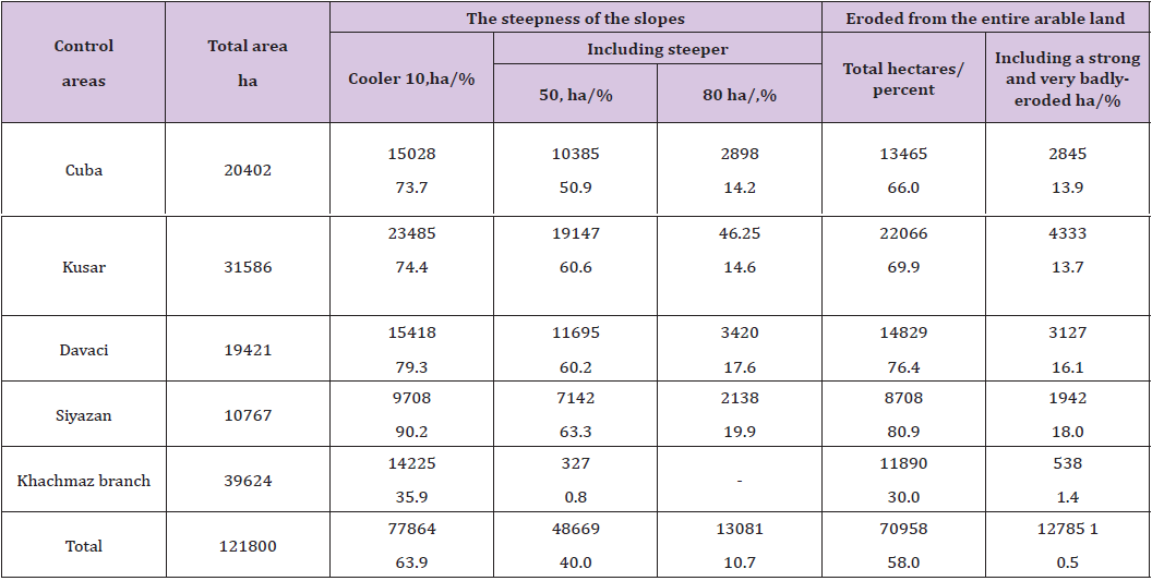
Table 2: Distribution of arable land on the steepness of the slopes and soil erosion administrative areas of the north-eastern part of the Greater Caucasus.
So when surveyed in the forest zone of Gorno-Brown soil stepped on one of the areas with a slope of 15-200 on the southern slope of the silnojerodirovannye soil, were found on the slopes of the Northern exposure with a slope of 15-200 -weakly eroded. It was found a great influence on the distribution of soil exposure. So on the slopes of the Northern exposure when slopes 8-120 Gorno- Brown stepped soils wash is 19.2 m/ha, while similar conditions southern exposure reaches soil washout 45.8 m/ha. If on the slopes of the southern exposure medium and silnojerodirovannye soils occupy 41.2% of the area, on the slopes of Northern exposure in similar circumstances-just 9.8%. Square units of each category and groups of eroded land have been calculated, taking into account the genetic soil types. As a result, became possible be explication of eroded land of Azerbaijan. In explicating contains data on the number of each type of eroded soils varying degrees of erosion on slopes or another surface, consisting of various agricultural land. Further synthesis of erosion of land is to bring them into the Republican maps, where, with the aim of zoning activities rise shows the dependence of the soil cover. To highlight eroded territories the following gradation of the basis for the allocation of eroded land.
Based on the data mapping of eroded soils, as well as the cameral works compiled map of soil erosion of the Azerbaijan Republic with the following application:
i. Do not subject to erosion under forests;
ii. Not prone to soil erosion, natural senekosom and occupied marsh vegetation;
iii. soil, confined to such lands, as deposits, gardens.
Depending on the amount of soil with varying degrees of destruction of genetic horizons lands are divided into five groups:
a. very little eroded land, where slabosmytye a difference constitute no more than 10% and sil’nosmytye soils are not available.
b. Slabojerodirovannye of the Earth, where the total area of eroded differences is 25%. Area slabosmytyh -20% srednesmytyh soil-not more than 5%, and sil’nosmytye soils are not available.
c. soil Srednejerodirovannye, Only up to 50% of eroded soils. Square of contours with medium soils jerodirovannymi reaches 30%, slightly eroded-to 15% and sil’nojerodirovannyh-up to 5% and very silnojerodirovannye is 10%.
d. Sil’nojerodirovannye soil, Jerodirovannost soils is about 75% of the total area. Of these, sil’nojerodirovannye-40%, srednejerodirovannye-to 25%, and very sil’nojerodirovannye-10%.
e. Highly sil’nojerodirovannye soils, Eroded area accounted for more than 75%. Very silnojerodirovannye-bolee50%, medium, sil’nojerodirovannye-more than 25%.
f. Given our experience, we fully share the views of F.s. Kozmenko, g.a. Presnyakova, S.s., Sobolev K. Alekperova, m.n. Zaslavsky that coloring the top layer of soil can be taken as the rate of erosion.
g. In nesmytyh -colour dark brown, humus content-5%, nitrogen-0.30%, fosfora_0, 22% capacity acquisitions-35mjekv per 100 g soil, structural units vodoprochnost’-mm over 1 km with 52%.
h. Very slabosmytye. Horizon and washed not more than 20%, the color of the soil a little different from nesmytyh (dark brown). Humus content in the upper horizon is 4.6%, nitrogen-0.28%, phosphorus-0.19% absorption capacitymjekv 32.5 per 100 g soil, the number of vodoprochnyh units over 1 mm 48%. Yields below 10% than that of nesmytyh.
i. Slabosmytye Horizon and from 20 to 50% washed soil color Brown, humus content-4%, nitrogen-0.24%, phosphorus-0.16%, absorption capacity-CIECA 28.8 per 100 g soil, amount of vodoprochnyh units-48%. Yields below (from 10 up to 25%) than nesmytyh soils.
j. Srednesmytye Horizon and washed away completely. soil color is light brown, humus content-2.8%-0.18% nitrogen, phosphorus-0.10% absorption capacity-23, 8mkjev to 100 g of soil, vodoprochnye units-30% yields below from 25-50% than that of nesmytyh.
k. Sil’nosmytye Wash off the horizon in1, the color of the soil -zhel’tovatyj with brownish tinge. The content of humus-1.2%-0.08% nitrogen, phosphorus-0.05%, absorption capacity is 14.5 to 100 g of soil CIECA, vodoprochnyh units-18%, yield-from 50 to 75% (Table 3).
l. Very sil’nosmytye Rinse off completely the soil layer on the surface of exposed, loose and hard woods.
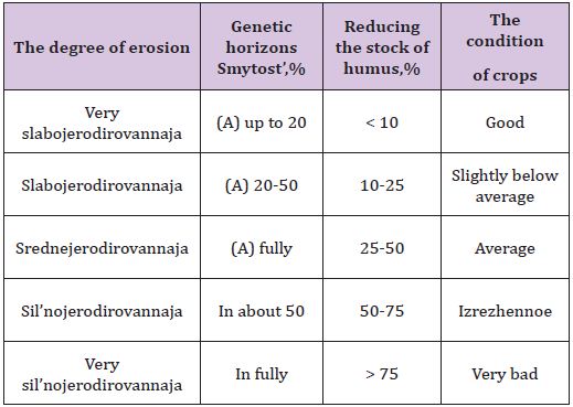
Table 3: The degree of soil erosion.
General provisions for the classification of eroded soils are the following: selection of diagnostic indicators to determine degrees of erosion of soil, suitable quantity allocated to degrees of erosion soil standards to ascertain their degree of erosion. Brown-soil erosion degree stepped is invited to determine to reduce genetic horizons and reduce the content of humus in the horizons of A+B. very weak jerodirovannym it is recommended to classify the soil in which compared to non-eroded observed reduction of the horizon and up to 20% and up to 10% of humus, to weakly jerodirovannym respectively 10-25% to srednejerodirovannym%, 25-50-sil’nojerodirovannym-50-75%. These gradations are offered, taking into account the variation in the humus content in soil and nesmytyh laboratory error definitions. Determination of the degree of erosion of soils based on quantitative change in humus content in the surface layer of soil-is an accurate and objective method that can be used in exposed soil mapping of mining-Brown soil and stepped close to him on the genesis of soils.
Natural hayfields and pastures, is constantly covered with vegetation, considered the most effective form of conservation lands.However, due to the deprivation of the protective cover on the slopes increased run-off of soil, which contributes to erosive process. In their geographical distribution of erosion on pasture appear in a certain area of subordination, which is confined to certain areas and bioklimaticheskim is a product of the evolution of the bioclimatic Wednesday. Depending on the degree of development of erosive process, the nature of vegetation and soil generic breeds, each selected type of erosion is divided into subtypes and variants. Grouping of eroded soils of the Republic covers the main naturallandscape zones, taking into account the landscape and climatic conditions of each zone.
Highland climate differs harsh long protracted winter snow and frost. Summers are short and cool. The average annual temperature does not exceed 3.2 -4.10, and the coldest month (January) range from -4.6 -7.90 c, the temperature of the warmest month (July) is low, ranging from 12.9 -13.70c; the sum of temperatures above 100 very low and average does not exceed 800-600. Duration of the frost-free period 1-2 months, vegetation period lasts 90-120 days. Average number of approximately 610-1210 mm, moisture ratio 1.52 -1.22, total solar radiation (annual) changes within 144-156 kcal/cm2. For the climatic indicators of the whole territory of the Highlands refers to wet (MD < 0.45) and cold (ΣΤ > 800) climatic type.
Floristic composition of the vegetation is extremely heterogeneous and varies with altitude. In the most elevated part of the vegetation canopy cover not provided-groups skalnoosypej (lichens, algae, etc.) For the Alpine meadows are typical plotnodernovye meadows with zlakovooskovymi components. Subalpine meadows are presented cenozami cereals, grasses, thickets of rhododendron, and in relatively dry parts of the Meadow-steppe communities. The main soil types are: mountainmeadow, mountain-forest-meadow and mountain-meadow-steppe. Agricultural production is weak, the zone largely occupied by wealthy summer pastures and mowed lands and are the basis for the development of transhumance (sheep) and fodder production. Alpine and subalpine meadows, the main area which is occupied by pastures, soil erosion is the factor, which is closely linked areas. Stripped of protective vegetation, soil sloping land can’t absorb the snow and rain water. This leads to an obsession with surface runoff which enhances ripple rivers. As a result of violations of the hydrological regime of the territory, which is due mainly to the removal of forest and grassy vegetation, knocking in the rivers of the mountain areas often seen very strong fluctuations in the volume of river flow. A large loss of water runoff regime of rivers worsens as snow, and especially power snegodozhdevogo. This, in its turn, reduces irrigation capacity of rivers on the territory of the foothill Plains, necessitates the use of large irrigation and reclamation work.
Erosive processes that resulted from the degradation of the vegetation of pasture, contributing to a sharp drop in the productivity of pastures. Therefore, soil erosion and deterioration in the quality of grass-processes are closely linked. A welldeveloped natural grass cover markedly increases the resistance of soils and erosion of the leachate may run off. Development processes of erosion affects not only the quantitative indicators of pasture plants, but also leads to a restructuring of phytocoenosis. From the total area of 2402.3 hectares of mountain pastures over 1985, 8 thousand hectares or 82.7% are prone to erosion. Pastures depending on subband and exposure of the slope wash soil varies ot50 to 125 m3/HA. From these studies derives great economical importance is the study of pasture erosion in mountainous areas and the development of techniques to prevent and fight against it. When developing differential measures for the improvement and rational use of pastures, there is always a need for classification and grouping of grazing land for their qualitative qualitative condition. It should be noted, however, that classification pasture erosion has now developed enough. Moreover, even the phenomenon of erosion on pasture do not found a definite place in the common grouping of erosive processes, although the nature of the manifestations of pasture erosion is very much different from other types or categories of erosion.
On the classification of eroded soils of mountain pastures known work Va Meeting, (1958), D.j. Mihjlova (1959), SwKerimhanova (1972). In these works gives grouping soils grazing on a degree as they are destroyed. In the forms of accelerated erosion caused by human activities, have a lot in common. However, according to and from the reasons caused the manifestation of erosion, these forms have their own characteristics. The character manifestation of soil erosion of mountain pastures pretty sharply differs from erosion on cultivated hillsides. Erosion processes on the pastures start to develop normally, since damage to the turf. Mountain pasture soil destruction process has no similarities with the formation of gullies and potholes. The length of the pits not always exceeds their width, and availability under lower-powered soil layer waterproof dense rocks brings not on no growth pits deep. Further growth in the size of erosion pits usually occurs through the broken walls, sliding down the slope of sod places preserved woven roots and reminiscent of education in the second stage of its development. Raised near each other erosive pits are often steep walls and expands, incorporate among themselves, forming patches or streaks of eroded soil. As the further destruction of the soil occurs more or less gradual alignment of bugorchatogo through the shedding of microrelief, and under the influence of runoff [1-6].
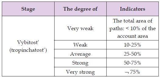
Table 4: Classification of pasture erosion on hillsides.
This specificity of the appearance of erosion on mountain pastures requires, firstly, providing pasture erosion in independent or category subtype, secondly, development of appropriate soil classification according to their level of erosion. Based on long-term observations, taking into account the peculiarities of the destructive processes of soils under the influence of the unrestrained grazing of livestock, it is proposed that the draft classification pasture erosion on erosion degree (Table 4). This includes the sequence of dernennogo deformation process layer. Research indicates the possibility of using cultural vegetation cropland and grass native grasslands in order to clarify the erosive soil survey data. On the plots under sowing of field crops traits for which you can define the degree of soil erosion are projective cover and height of plants. With passion steepness of slopes the ability to use crops as indicators of soil erosion is reduced. The degree of soil erosion of natural grassland can be estimated based on existing dependencies between the grass plants and extent of soil erosion. Pretty strong jerodirovannost soils of sloping meadows can be recognized for environmental regimes of vegetation habitats.